

Post by OnlyMark on May 7, 2019 18:40:03 GMT 2
From a bird's eye perspective, this is Lusaka city centre.
Flat, dusty and fairly unattractive. There are patches of green as you go further out and most of the roads have trees along their edges - but - there is a decongestion project going on at the moment and a lot of the trees are being cut down for road widening.
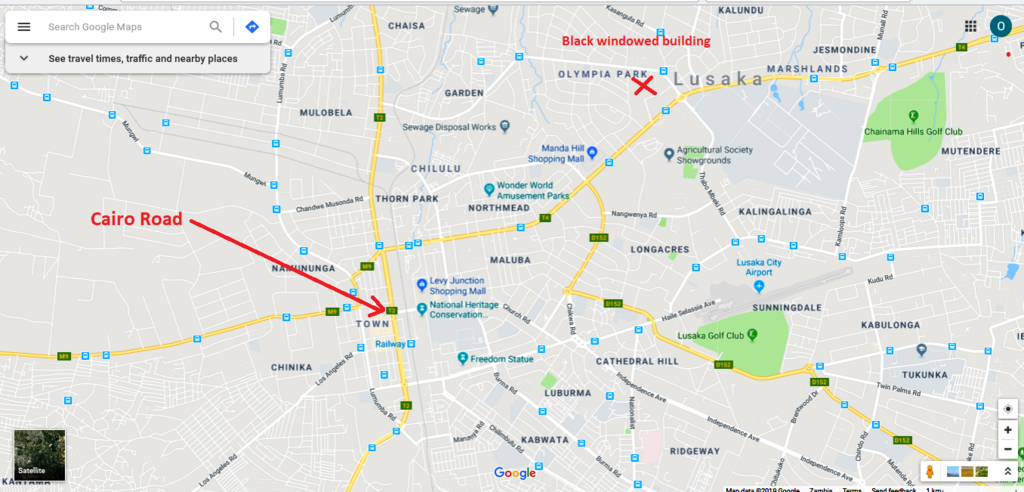
The very opening of the two minute video shows, barely discernible, the railway running north to south. At 13 seconds it cuts to the main north/south road (looking south) and shows the tall building with the red signs on the top again as a few seconds ago. This road is Cairo Road - the road and the railway were instigated by Cecil Rhodes and was supposed to run from Capetown to Cairo.
It is a dual carriageway and you will find it is of standard width - as are many town/city centre roads in southern Africa - the standard being that it is possible turn around a trek wagon pulled by a team of oxen, in one move.
What you see for those few seconds is the entirety of the dead centre of the city. Quite unimpressive and an area I tend not to visit after the first few times. It is called the CBD, the central business district.
The film must have been shot before the rains as everywhere does look particularly dry and brown.
You can see how flat the whole place is.
At 1:39 you start to see a large black windowed building. I live within a short walk of this.
At 1:42 you get a shot of the building and on the horizon far right, you can see several tall building in the distance. This is where the drone has just come from in the centre. Close by to the building are a couple of shopping malls I tend to frequent and have mentioned in posts before.
For orientation -
Flat, dusty and fairly unattractive. There are patches of green as you go further out and most of the roads have trees along their edges - but - there is a decongestion project going on at the moment and a lot of the trees are being cut down for road widening.
The very opening of the two minute video shows, barely discernible, the railway running north to south. At 13 seconds it cuts to the main north/south road (looking south) and shows the tall building with the red signs on the top again as a few seconds ago. This road is Cairo Road - the road and the railway were instigated by Cecil Rhodes and was supposed to run from Capetown to Cairo.
It is a dual carriageway and you will find it is of standard width - as are many town/city centre roads in southern Africa - the standard being that it is possible turn around a trek wagon pulled by a team of oxen, in one move.
What you see for those few seconds is the entirety of the dead centre of the city. Quite unimpressive and an area I tend not to visit after the first few times. It is called the CBD, the central business district.
The film must have been shot before the rains as everywhere does look particularly dry and brown.
You can see how flat the whole place is.
At 1:39 you start to see a large black windowed building. I live within a short walk of this.
At 1:42 you get a shot of the building and on the horizon far right, you can see several tall building in the distance. This is where the drone has just come from in the centre. Close by to the building are a couple of shopping malls I tend to frequent and have mentioned in posts before.
For orientation -


